Monday, June 30, 2014

And oh, by the way, those are (maybe) nuclear.

Nike Site SF-88, Creative Commons Credit License, edited.
While Bangor had Dow AFB and its collection of supersonic, unmanned, "nuclear capable" interceptors in the Bomarc Missile base adjacent to the site, Loring AFB had a collection of four Nike batteries in Caswell, Limestone, Caribou and Van Buren. Only Caswell and Caribou sites had the Hercules designation (this is important, for later...)

The Nike Hercules was a very capable surface to air, surface to surface and anti-missile weapon used by the US Air Force. Compared to the Bomarcs in Bangor, it had a smaller operational range (90mi as opposed to 260mi) but higher service ceiling (150,000' instead of 65,000 ft) and a speed of mach 3.6 instead of 2.5.

To put it in perspective, the Nike could fly from Bangor to Augusta in one minute and fifty seven seconds, but then it would run out of fuel.

Of course, the batteries of supersonic missiles surrounding Loring AFB weren't the site's only defense, as it deployed helicopter gunships during its 1975 UFO incident and was the garrison for the 27th Fighter Squadron and their F-106 Delta Darts between 1959-1971, and the 101st Fighter Squadron thereafter.

What makes Caswell and Caribou different? These were likely nuclear facilities, unbeknownst to their host communities. A declassified memo from the Commander In Chief of Continental Air Defense Command (CINCONAD) from the time of the Cuban Missile crisis reads as follows:

Rules of engagement for the Florida area prescribe the use of high explosive weapons only. In the event of an IL-28 raid from cuba which penetrates US Air Space, I consider it imperative to use weapons with a maximum kill capability. Ref a. and b. authorize CINCONAD to eimploy (sic) nuclear weapons in air defense within the sovereign boundaries of the us, its territories and possessions, and in the coastal adiz, subject only to currently approved rules for engagement.

Remember, rules of engagement specify high explosive warheads (read: conventional weapons as opposed to nuclear) for the Florida area only. The memo continues...

Request clarification of my authority to declare cuban/sino-soviet tactical aircraft 
"hostile" under ref c and to use nuclear weapons, both before and after cinclant oplan (??) 312-61 is implemented. Should a raid from Cuba penetrate the air defense identification zone or sovereign boundaries of the US, YOUR ATTENTION INVITED TO THE FACT THAT IN MOST LOCATIONS NIKE HERCULES UNITS HAVE NO REPEAT NO HE WARHEADS.
TL;DR - if sh*t hits the fan I'd like to indirectly remind you that if you ever fire these, you're going to spread radioactive fallout all over the region in which you're operating.

Here's a bird's eye view of one of the sites in Caribou. And an awesome exploration of a Nike site in Limestone over at ColdWarRelics.com

Nike Launch Site L-58, Caribou ME.

Memo courtesy of the Loring Reading Room.

Saturday, June 28, 2014

Civil Defense Bunker | Milo


Awhile back, I posted about the Old Town civil defense bunker -- a facility built in the early 60s that would have helped coordinate evacuation of citizens from 'risk' areas to 'shelter' areas if the Soviets were to glass Bangor. There is another, identical, bunker in Windham -- but it's still in use by Cumberland County, and their director doesn't seem keen on tourists. Where does that leave us? With the only one of two CD bunkers still "open." (Open by virtue of not having been filled with concrete.) So, on a beautiful June afternoon I gathered a small away team and took a drive up to take a look at the Milo Civil Defense bunker. When we arrived we found that the Piscataquis Amateur Radio club was having their annual field day. Much to our luck, they were kind enough to show us around.

The bunker in Milo is like the bunkers in Old Town and Windham; a result of a need to create contingency plans to protect citizenry in the event of Soviet nuclear attack. It's served as a soup kitchen, and has been operating again (kind of) in its original capacity since 2002 as it is the site of a radio transmitter designed to provide information to locals in the event of emergency. Additionally, the radio club is quite active, and the soup kitchen there still serves the community.

The blue portion of the logo appears
to have been long gone.  
The condition of this bunker is striking, even some of the furniture appears to be original. Long, low tables, period task chairs (not pictured) and a stylized but rough logo on a podium lend themselves to an eerily (but unintentional) period feel. The concrete beams of the ceiling are omnipresent within the structure, but partitions and doors are erect.

The partitions may be original, as the only reference in local news to renovation is regarding the facility's kitchen and code upkeep. News stories reference flood damage in the late 1980s, but none of it is apparent.

Several agencies have transmitters onsite including local law enforcement, NOAA, and the county emergency management agency. There's still a generator and working plumbing. If a bomb were to drop, these guys may be ready to go.  Or at least they'd probably live longer...

Using google's newspaper archive, I've put together a short timeline of the bunker's history since its construction in the early 60s:

An old punch down block and phone demarc.
October, 1987 - a Bangor Daily News article reveals that the facility is the target of budget cuts after it had flooded in April of 1987, and it was found that the telephone system present in the "complex" (BDN's word, not mine) wasn't advanced enough to allow itemization of phone calls.

June, 1989 - the county considers closing the bunker. It was used as the site for the sherriff's communications equipment, some emergency management functionality, and at the time it was also considered as an adult ed center.

November, 1991 - the bunker's future balanced on the edge of a county commissioner's chopping block, again...

November, 1993 - the county talks about closing it. Again.

November, 1998 - The kitchen of the bunker is considered for use in charity work by the Eastern Agency on Aging. From the sign on the photo above, they appear to have chosen it.

September, 1999-  Piscataquis county spends $10,000 ($14,230 adj for inflation) to renovate the bunker to serve as a kitchen. By contrast, Penobscot county spent $20,000 in 1986 ($43,261 adj) to renovate their bunker into a jail.

March, 2002 - the bunker gets additional roles as the location of an emergency NOAA transmission site.

April, 2003 -  Emergency Management Agency holds a free weather-spotter course at the bunker.

The photos are below. To see a larger version of each photo, click on it. Your scroll wheel will also flip through the gallery.

A routing area for wires to the antennae. 

Two showers for 35 people. 
Note the light fixtures. 
Buildings for ventilation and utilities. 
A small exit door leads to an escape hatch above ground. 
Conduit for the antenna wires. 

Thursday, June 26, 2014

Globecom, Pre Internet email | Perham

This site is considered by its locality to effectively be off limits. The content in this post is an aggregate, and original sources are linked throughout. Click here for more information. 

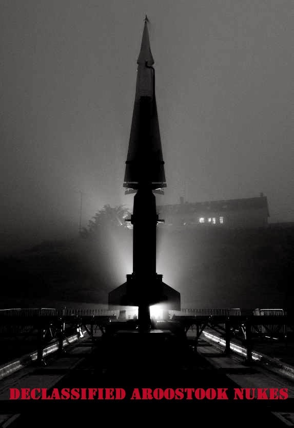
In the woods of Perham, ME (population around 500), you'll find a component of the very first world wide communications network, crumbling and covered in graffiti. While this site may be one of many like it across the globe it's noteworthy in that, in addition to the SAGE blockhouse at Brunswick AFS, it was yet another example of Maine's location relative to the Soviet threat of the time causing us to be on the forefront of communications, technology, and defense.


Long before you could push a button on your komputerphone and within seconds be on your way to all the cat videos you could ever want, you had to use a modem to look at cat pictures. A modem was a device that modulated/demodulated analog tones for direct communications with another computer. Before using a modem to look at cat pictures, you had to use an acoustic coupler so your computer could send tones over plain old telephone service to gain access to text-only cat stoires. And before that having to use an acoustic coupler? You were kind of SOL if you wanted to use the "internet" as it was before then, unless you were in government or academia you had to use ARPANet, the world's first packet swtiched network. Before ARPANet if you wanted to send messages across the world, you had to send them for a very specific purpose and from very specific locations using a series of short-wave, high frequency, trunked radio networks or use a store-and-forward torn tape system that effectively routed information Western Union style across the globe.

Take a look at the floor plan below and the shape will make a lot more sense.

Comm complex layout at virihistory.com

This site was a big deal for several reasons. Foremost GLOBECOM (Later to be renamed STRATCOM) was the manifestation of a change in strategy resulting from the Korean War that reorganized communications from a structure relying on a theater commander with singular control to a structure relying on functional control. That meant for the first time that commands had instantaneous control of their assets more or less whenever they wanted. Anything from scheduling refueling, airlift ops, communications during an "alert", weather information or even reconnaissance. This building is a part of the very first system to allow that sort of geographically widespread, instantaneous communication. GLOBECOM brought the state of internet-like communication from a network of single channel voice/teletype/tape relays to a robust analog high frequency network.

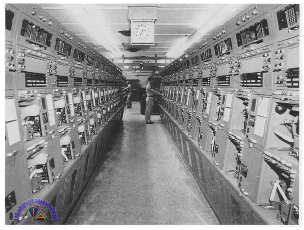
GLOBECOM/STRATCOM interior via Flickr
GLOBECOM/STRATCOM interior of a similar site in Germany. Usarmygermany.com
As the Perham site was active from 1955-1962 (here's an aerial image from 1953 showing an empty field), it conceivably would have had a few different capabilities as technology improved. Above is a photograph of a site in Germany with a similar purpose. The consoles lining either side of the hallway were a part of the militarized version of Western Union's Plan 55 in which precursors to serial modems would store, analyze and route messages stored on paper tape between sites. By the late 1950s high frequency microwave communications would have taken the place of analog torn tape routing, but, there is very little evidence of microwave transmission equipment visible from the air compared to other sites with more recent histories. A topographic map from 1963 does hint at the presence of microwave equipment; and I don't use AdWords so this falls under a non-commercial use ;)

HistoricAerials.com in case you missed it. Non-commercial use.
See those circles going along both sides of the road and coming to a point? Aerial imagery from 1996 when compared to the above topo image from 1963 leads me to believe that there was HF microwave transmission equipment there at one time.  

These circles on the map to the left are the only clue I have been able to find as to whether or not the air force did end up upgrading this facility away from Plan 55.


Take a look at the aerial image on the right from 1996. The roads to the north have the same shape and bearing as the circles on the topo map, which is not visible in more current aerial photos.

There are also concrete conduit bases onsite heading in the direction of the circles just mentioned. They're visible in the photographs below. Although these could have also been for HVAC as I have no detailed layout specific to the original site, whether or not the Air Force had found the time to upgrade this facility, and the 2192nd Communications/AACS Squadron away from Plan 55 is conjecture.

Suffice it to say that between the 'circles' on the topo map from 1963, the aerial images from  33 years later, and these apparent conduit beds leading in the direction of what would have likely been antennae, I'd be willing to conjecture that yes - the Air Force did upgrade this facility from Plan 55 to microwave communications.

All-Hazards.com, used with permission (Click to Enlarge)

While on the topic of conjecture, below is a handy map to show you just how far this one communications facility could theoretically reach if outfitted with HF Microwave equipment (3000 miles) . That green spot? The communications radius of the facility's reach. The blue dot? That's Perham. Again, comparing the '63 topo map to the '96 photo, it's possible.

Freemaptools.com Radius tool
 Between 1955 and 1962 this site was manned by the 2192d AACS Squadron (later to be named the 42nd Communications Squadron) Other information from local media is scant....
  • May, 1961: The Lewiston Daily sun reports that the Communications Annex (Perham Globecom) and "Receiver B" in Caribou were to be closed. 
  • November, 1990: The Bangor Daily News reports the death of two in a small plane crash. They crashed on the access road to the facility. Authorities were unable to find any mechanical failures.
Apart from the opening in 55 and the closure in 62,  that's really all there is on the web regarding this site apart from pictures taken long, long after the fact.  Here is a sample of what's available over at All-Hazards.com and this particular Loring Legend entry.

Click any of the photos to enlarge them.
"Wade, you're a big puss for not goin' to the titty bar with us"

This would have been aclatter with state of the art period electronics.
According to blue prints, receiving and storage?
Evidence of an awning on the front.
This would have been outside the tape relay area.
Standing on the lobby, looking at the auto-switching area (according to layout), with the shop on the far right in the back.
It should be said that since some yahoos have spray painted it and had a few fires, that the locals (and perhaps the constabulary) don't really want people going out there.

Resources and sources:

Loring Legends Entry for Globecom
42nd Communications Squadron Factsheet
2192 AACS/Communications Squadron Patch
AACS Alumni Association 1938-2004
HistoricAerials map.


Wednesday, June 18, 2014

Radar Bombing Range | Ashland


On February 23rd, 1967, an allegorical soap opera you may have heard of called 'Star Trek' aired an episode in which computers were to determine the damage done by a virtual attack, and orders were issued for the casualties of said virtual attack to be killed. Fortunately, in the real world, we used computers and other equipment to simulate and determine damage done by an attack -- without requiring casualties to report for extermination.

From the 70s through the early 1990s the town of Ashland was host to a high tech virtual bombing range. Keep in mind this wasn't a live bombing range like Milford ; if that were the case the Aroostook River valley would have been a dry, irradiated crack. These bombing runs were all done by computer and radar, with some help from a B-52 in the air. This article from the range's closure in 1992 states that the facility had a 1000 square mile effective "combat" rage and a "sophisticated emitter system and radar used to determine accuracy of weapons delivery systems."

According to a local, before the Ashland radar range was a brick-and-mortar (and barbed wire) site it was a bunch of truck trailers sitting on the top of a hill. Apparently, back during the 60's the crew apparently were willing to indulge any locals that wanted a tour. Fortunately, The County was probably too cold for Soviet Operatives. 

Balmy.
The first reference I can find to the Ashland radar site in local media was on April 3rd, 1973 when the Bangor Daily News ran a small piece titled "Ashland Target of Mock Bombs" in which it described several B-52's flying over the town, "dropping" bombs - which were really just electronic tones to show up on a radar screen. At this point the site was mobile and appeared to be somewhat tertiary to the Louis Blotner Bomb Scoring Range farther to the north in Caribou.

According to this Bangor Daily article from 1975, the site was responsible for scoring simulated bomb drops as well as for determining the theoretical efficacy of attempts to penetrate enemy defenses with electronic countermeasures. B-52s would fly over the site, the RBS (Radar Bomb Scoring) facility would lock onto them as they flew over Ashland between Bangor and Houlton. A tone would be transmitted between the bomber and the scoring site to analyze the 'bombing run.' The site brought 50 people into the sleepy town to work, and was planned to remain in existence even after significant winding down of forces at Loring AFB.

50-60 People would commute from Presque Isle to here, passing through this gate.
Bombers would fly proximate to the facility, simulating bomb drops - and the facility would simulate the return of electronic countermeasures (basically, trying to mess with the bomber's navigational systems.)

This article from 1979  indicates that the Ashland radar site is indeed a separate facility from the Louis Blotner Bomb Scoring Range. It also notes that the site was the first to bring together "operations, maintenance, power, training, administration and the commander under one roof." This BDN article from 1978 indicates that the site in Ashland is actually quite low key, "the project consists of a 72 by 77- foot single-story cement block building."

During its time operating in Ashland the site wasn't without a bit of notoriety; it was a part of some pretty significant war-game like activity in 1983. It won a national award in 1985 for its role in "helping (the) bombers make precise hits relatively close to enemy lines" through the training exercises in which the site was crucial.

Additionally, my local source would go on to state that he would take great pleasure in watching the B-52's buzz over at such a low altitude, but also indicated that he'd occasionally see B-52 sized craft (according to running lights) but with no sound. No local media indicated the presence of B-2 Spirits in the region during that time.The site was deactivated in 1993, and transferred to the [REDACTED] by the General Services Administration in 1999 after talk of becoming a broadband internet communications hub in 1996. The broadband communications hub idea didn't get off the ground.

With permission from the organization that now has control of the Ashland bombing range, I went to the site and took the photographs you saw in this post. I've done my best to remove direct references to the site's location as business still goes on there - granted, business of a wholly different nature. The barbed wire fence appears to be original to the site.

Sunday, June 8, 2014

Grab bag: Mainers Working Smarter

When you think of famous people from Maine, you think of Stephen King, Patrick Dempsey, or Bob Marley (you know, the guy that Willem Dafoe was hilariously awful to in Boondock Saints.)

In addition to faces you've seen, there are a great number of devices or products you're likely familiar with that have origins here. Mainers are great at working smarter, and not harder:


Hiram Maxim, Sangerville native, invented a machine that let you poke holes in a lot of people from far away.The Maxim Machine Gun was invented in 1884 and used a gallon bladder full of water around the barrel for cooling, and was used by the English, the Germans (Maschinengewehr) and the Russians (Pulemyot Maxim.)
Wikimedia Commons
Perry Spencer, a Howland native, invented the microwave oven. Spencer was a guy who was orphaned by twelve and supported himself by working in a nearby spool mill (either in Howland or South Lincoln) until he was sixteen. He was a self taught electrical whiz who managed to teach himself trigonometry, calculus, chemistry, physics, and metallurgy, among other subjects. He was a pioneer in radar design at a time when the technology was fledgling, and ended up winning the Distinguished Public Service award for his work on development of combat radar. He invented the microwave more or less by accident, after noticing the effect some of his radar equipment had on a bar of chocolate in his pocket. The clincher? He was paid a one time $2 by Raytheon for his invention and his home town now prides itself on being the home of Matt Mulligan...
Also, he also shoulders a small about of blame for Hot Pockets. 
Chester Greenwood of Farmington strapped bits of dead beavers to his head to keep his ears warm back in 1873 at the age of fifteen. We now call these earmuffs, and they save us from having to cut a Partridge open like a Tauntaun and then wearing it on our heads to keep warm. Farmington still has a Chester Greenwood day every December.
Vermont native Daphne Zuniga modeling a version of Greenwood's invention. Kind of.
Alvin Lombard Waterville invented tracks while designing his Lombard Log Hauler. ...sort of. I can't claim that he was the sole inventor, but he was the very first to use tracks in a commercial application successfully. Holt Tractor, the company credited with giving Renault its track design for the very first 'modern' tank, incorporated tracks in their designs a full sixteen years (1917) after Lombard successfully used them on the Log Hauler. Alvin Lombard gave birth to an idea that helped northern woodsmen haul unfathomable amounts of product for the time that eventually ended up in the battlefields of Europe (the tracks...not the wood.) It's really a fascinating machine, with a short, paradoxical existence deserving of its own entry.

Paradoxical in that the technology later made its way into bulldozers, which could construct passable roads, rendering the log hauler obsolete. Below are Lombard's log haulers in various states of repair.

http://www.panoramio.com/photo/64006457
MaineEncyclopedia

Bangshift (SFW, I promise) 
A note on the guy up front on the steam powered unit - he was one of a crew of four. One in the back (a brakeman), an engineer and fireman to stoke/fuel the fire, and the guy who got stuck with the job of steering a 19 ton steam powered behemoth (with no brakes) that was hauling 300 tons of wood downhill (as all logging roads of the era due to previous animal constraints.)

Helen Augusta Blanchard invented the zig-zag sewing machine. She's been described by some as a "Lady Edison"  Blanchard was from a wealthy family and 22 of her 28 patents were sewing related.

Milton Bradley (yes, the board game guy) was born in Vienna, Maine. He didn't start his business in Maine, but without him we'd not have memories of arguing about Battleship, now would we?

The inventors of the first green car were from Kingfield. However, the first Stanley Steemer was built in New York. The Stanley museum in Kingfield still operates, however.
Blazing fast country guitarist Johnny Hiland grew up in Woodland, went to USM until he dropped out and moved to Nashville. He's backed "country" acts like Randy Travis and Toby Keith, and has backed country acts like Hank 3. He's got endorsements from Fender, Ernie Ball and Elixir, which is impressive considering he did it without riding the coattails of a conventionally attractive vocalist and skill purchased from the likes of Berkelee (sorry Karmin.)

Sunday, June 1, 2014

Cushman's Ridge | Springfield

Nestled between the potato fields and SAGE System gap fillers of Presque Isle to the north and the remains of mill towns dotting the Katahdin Valley corridor to the South, you'll find the somewhat sleepy town of Springfield. However, in the woods off of State Rt 6, you'll find "suburban sprawl" from the time of the Civil War.

The red diamond indicates the old site of School No.6 - for reference
This area attracted my attention because of a forgotten grave yard. To call it 'forgotten' wouldn't quite be accurate. Someone was buried there as late as 2000, although one wonders quite how they managed to thread a thirty foot long Cadillac down a road like that (perhaps the supernatural really is at work up there). More recently, another blogger has raised some questions about this location by recalling some local ghost stories -- the cemetery is on the Ghost Rd, after all.
Old timers claim that a young blonde haired girl was riding her bike along the ghost road when she encountered a woman in a horse and carriage.The woman reportedly stopped to offer the young girl a ride.
The little girl peered into the old woman's bright green eyes and told her she was not allowed to ride with strangers. Upon returning home the frightened girl relayed the story to her parents, who told her the woman was the green eyed witch and to keep her distance.
Sometime later the young girl decided to take another ride on her bike – but she never returned. When her parents set out to find her, all they uncovered was an abandoned wagon with the little girl's bike cast to the side. The little girl and the green eyed witch were nowhere to be found.
-Collected by Nannette Richford

The author has provided several rather colorful anecdotes related to the communities relationship with the cemetery at the Cushman Ridge settlement. Most interesting is the story about a freak storm falling upon a survey crew, as the nearby Mt Jefferson likely isn't tall enough to produce meteorological phenomena like rain shadows. Whether or not you believe in that kind of thing, and personally I don't, it's nonetheless interesting.  

Ghost Road is perhaps a very apt name. Imagery from 1875 shows the location of the cemetery, as well as two adjacent schoolhouses, a 'town farm' and what appears to be a retail establishment named Butterfield & Scribner. In fact, the place looks downright packed compared to its population today.

HistoricMapWorks.com
Note that the area depicted is not the "village" on Rt 6, but is instead the network of 'trails' to the south of Rt 6. The red diamond on the map was added by me, as the intersection of those two unnamed streets is still present, and visible in the photo at the header of this post.

This 'ghost town' is a bit of a different animal than the others. It wasn't a frontier like Patten or Sherman, and the town played no significant defensive role (geographically.) In an effort to track the development and subsequent decline of this area, I've searched the initials/names of the residents listed on the map through Google's newspaper archive search and scoured aerial photos for evidence of ruins. First, the good news -- there is evidence of ruins other than the cemetery.

I have yet to visit this area, these are oddities in the woods proximate to the settlement. The only house I've been able to find that's still standing and labeled on the map from 1875 is below:
I am with holding the coordinates at this point, as I haven't been out there to see whether or not this is a really big camp or if this is exactly what it looks like: A large house in the middle of the woods with no shadows indicating power lines, and no evidence of automobiles. I believe this to be the residence of E. McGuire, judging by the map farther up in the post -- although I understand this may not be abandoned despite having no driveway and no power lines.

Below is another I'm holding onto coordinates for...again, that's awfully big for a camp...and is that a steeple?


Also, there appears to be another structure in the area at [REDACTED FOR NOW]. This one took me a moment to find.


The highlighted object casts a shadow significantly shorter than the trees around it, additionally the tree above it casts a shadow on a uniform, rectangular patch of color. There appears to be a lawn to the south, and two white objects (fenceposts? graves?) to the north. This area does not appear on the map from 1875. 

Of course I do realize that it's entirely possible that I will go out there and encounter folks who just like living away from services and infrastructure, in which case I'll visit the graveyard and be on my way. Even if these houses are occupied, I can still observe the graves of two (Union) Civil War soldiers: Abra(ha)m Kneeland (1772-1846) and 1st Cavalry Sgt Thomas McGinley(1812-1892).

This site is definitely one which I am going to visit this summer.