Sunday, June 8, 2014

Grab bag: Mainers Working Smarter

When you think of famous people from Maine, you think of Stephen King, Patrick Dempsey, or Bob Marley (you know, the guy that Willem Dafoe was hilariously awful to in Boondock Saints.)

In addition to faces you've seen, there are a great number of devices or products you're likely familiar with that have origins here. Mainers are great at working smarter, and not harder:


Hiram Maxim, Sangerville native, invented a machine that let you poke holes in a lot of people from far away.The Maxim Machine Gun was invented in 1884 and used a gallon bladder full of water around the barrel for cooling, and was used by the English, the Germans (Maschinengewehr) and the Russians (Pulemyot Maxim.)
Wikimedia Commons
Perry Spencer, a Howland native, invented the microwave oven. Spencer was a guy who was orphaned by twelve and supported himself by working in a nearby spool mill (either in Howland or South Lincoln) until he was sixteen. He was a self taught electrical whiz who managed to teach himself trigonometry, calculus, chemistry, physics, and metallurgy, among other subjects. He was a pioneer in radar design at a time when the technology was fledgling, and ended up winning the Distinguished Public Service award for his work on development of combat radar. He invented the microwave more or less by accident, after noticing the effect some of his radar equipment had on a bar of chocolate in his pocket. The clincher? He was paid a one time $2 by Raytheon for his invention and his home town now prides itself on being the home of Matt Mulligan...
Also, he also shoulders a small about of blame for Hot Pockets. 
Chester Greenwood of Farmington strapped bits of dead beavers to his head to keep his ears warm back in 1873 at the age of fifteen. We now call these earmuffs, and they save us from having to cut a Partridge open like a Tauntaun and then wearing it on our heads to keep warm. Farmington still has a Chester Greenwood day every December.
Vermont native Daphne Zuniga modeling a version of Greenwood's invention. Kind of.
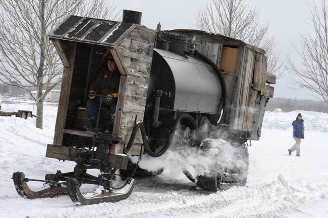
Alvin Lombard Waterville invented tracks while designing his Lombard Log Hauler. ...sort of. I can't claim that he was the sole inventor, but he was the very first to use tracks in a commercial application successfully. Holt Tractor, the company credited with giving Renault its track design for the very first 'modern' tank, incorporated tracks in their designs a full sixteen years (1917) after Lombard successfully used them on the Log Hauler. Alvin Lombard gave birth to an idea that helped northern woodsmen haul unfathomable amounts of product for the time that eventually ended up in the battlefields of Europe (the tracks...not the wood.) It's really a fascinating machine, with a short, paradoxical existence deserving of its own entry.

Paradoxical in that the technology later made its way into bulldozers, which could construct passable roads, rendering the log hauler obsolete. Below are Lombard's log haulers in various states of repair.

http://www.panoramio.com/photo/64006457
MaineEncyclopedia

Bangshift (SFW, I promise) 
A note on the guy up front on the steam powered unit - he was one of a crew of four. One in the back (a brakeman), an engineer and fireman to stoke/fuel the fire, and the guy who got stuck with the job of steering a 19 ton steam powered behemoth (with no brakes) that was hauling 300 tons of wood downhill (as all logging roads of the era due to previous animal constraints.)

Helen Augusta Blanchard invented the zig-zag sewing machine. She's been described by some as a "Lady Edison"  Blanchard was from a wealthy family and 22 of her 28 patents were sewing related.

Milton Bradley (yes, the board game guy) was born in Vienna, Maine. He didn't start his business in Maine, but without him we'd not have memories of arguing about Battleship, now would we?

The inventors of the first green car were from Kingfield. However, the first Stanley Steemer was built in New York. The Stanley museum in Kingfield still operates, however.
Blazing fast country guitarist Johnny Hiland grew up in Woodland, went to USM until he dropped out and moved to Nashville. He's backed "country" acts like Randy Travis and Toby Keith, and has backed country acts like Hank 3. He's got endorsements from Fender, Ernie Ball and Elixir, which is impressive considering he did it without riding the coattails of a conventionally attractive vocalist and skill purchased from the likes of Berkelee (sorry Karmin.)

Sunday, June 1, 2014

Cushman's Ridge | Springfield

Nestled between the potato fields and SAGE System gap fillers of Presque Isle to the north and the remains of mill towns dotting the Katahdin Valley corridor to the South, you'll find the somewhat sleepy town of Springfield. However, in the woods off of State Rt 6, you'll find "suburban sprawl" from the time of the Civil War.

The red diamond indicates the old site of School No.6 - for reference
This area attracted my attention because of a forgotten grave yard. To call it 'forgotten' wouldn't quite be accurate. Someone was buried there as late as 2000, although one wonders quite how they managed to thread a thirty foot long Cadillac down a road like that (perhaps the supernatural really is at work up there). More recently, another blogger has raised some questions about this location by recalling some local ghost stories -- the cemetery is on the Ghost Rd, after all.
Old timers claim that a young blonde haired girl was riding her bike along the ghost road when she encountered a woman in a horse and carriage.The woman reportedly stopped to offer the young girl a ride.
The little girl peered into the old woman's bright green eyes and told her she was not allowed to ride with strangers. Upon returning home the frightened girl relayed the story to her parents, who told her the woman was the green eyed witch and to keep her distance.
Sometime later the young girl decided to take another ride on her bike – but she never returned. When her parents set out to find her, all they uncovered was an abandoned wagon with the little girl's bike cast to the side. The little girl and the green eyed witch were nowhere to be found.
-Collected by Nannette Richford

The author has provided several rather colorful anecdotes related to the communities relationship with the cemetery at the Cushman Ridge settlement. Most interesting is the story about a freak storm falling upon a survey crew, as the nearby Mt Jefferson likely isn't tall enough to produce meteorological phenomena like rain shadows. Whether or not you believe in that kind of thing, and personally I don't, it's nonetheless interesting.  

Ghost Road is perhaps a very apt name. Imagery from 1875 shows the location of the cemetery, as well as two adjacent schoolhouses, a 'town farm' and what appears to be a retail establishment named Butterfield & Scribner. In fact, the place looks downright packed compared to its population today.

HistoricMapWorks.com
Note that the area depicted is not the "village" on Rt 6, but is instead the network of 'trails' to the south of Rt 6. The red diamond on the map was added by me, as the intersection of those two unnamed streets is still present, and visible in the photo at the header of this post.

This 'ghost town' is a bit of a different animal than the others. It wasn't a frontier like Patten or Sherman, and the town played no significant defensive role (geographically.) In an effort to track the development and subsequent decline of this area, I've searched the initials/names of the residents listed on the map through Google's newspaper archive search and scoured aerial photos for evidence of ruins. First, the good news -- there is evidence of ruins other than the cemetery.

I have yet to visit this area, these are oddities in the woods proximate to the settlement. The only house I've been able to find that's still standing and labeled on the map from 1875 is below:
I am with holding the coordinates at this point, as I haven't been out there to see whether or not this is a really big camp or if this is exactly what it looks like: A large house in the middle of the woods with no shadows indicating power lines, and no evidence of automobiles. I believe this to be the residence of E. McGuire, judging by the map farther up in the post -- although I understand this may not be abandoned despite having no driveway and no power lines.

Below is another I'm holding onto coordinates for...again, that's awfully big for a camp...and is that a steeple?


Also, there appears to be another structure in the area at [REDACTED FOR NOW]. This one took me a moment to find.


The highlighted object casts a shadow significantly shorter than the trees around it, additionally the tree above it casts a shadow on a uniform, rectangular patch of color. There appears to be a lawn to the south, and two white objects (fenceposts? graves?) to the north. This area does not appear on the map from 1875. 

Of course I do realize that it's entirely possible that I will go out there and encounter folks who just like living away from services and infrastructure, in which case I'll visit the graveyard and be on my way. Even if these houses are occupied, I can still observe the graves of two (Union) Civil War soldiers: Abra(ha)m Kneeland (1772-1846) and 1st Cavalry Sgt Thomas McGinley(1812-1892).

This site is definitely one which I am going to visit this summer.


Thursday, May 22, 2014

The Woodland Castle | Greenbush

The Woodland Castle: A resort half a hour north of Old town
If you follow old rail routes through Old Town, Milford, Costigan, Greenbush, Olamon, Howland, Enfield, Lincoln...etc... you'll inevitably stumble across evidence of bygone attractions peppering these towns and their histories. Above is a hotel either called the "Woodland Castle" or "American House" depending who and when you ask --  an interesting resort type property that was remembered merely as an abandoned structure by many Gen X-er locals (it was torn down before Gen Y could notice...) and remembered fondly by the Boomers and Silent Generation as *the* destination between Lincoln and Old Town.

According to local lore found in a Facebook thread, back when this attraction was built, B-17s were leaving Bangor for Europe, log drives on the river were still legal, Old Town was still making canoes, textiles & solo cups before they were called solo cups. A thread on the Facebook group "You know you grew up in [REDACTED] when" had uncovered some interesting memories of locals regarding this attraction:


The user in red is a Gen Xer, the remainder are Baby Boomers or older. Even as a child, I remember seeing the remains of this structure as I passed it on the school bus -- I had never known that over its history it had been a resort, a single family housing unit, and an abandoned structure for children of the 1980s to "scare the crap out of each other" in.

Scant information about this is available online -- there's not even anything on MaineMemory.net, which is an otherwise invaluable resource.Also, there's nothing left to explore -- the thing was torn down in the early 1990s. The turnout off of the main road was where the "castle" used to be, before it was demolished and burned.

© USGS
Is it so simple as an open and shut "built in the 40s and torn down in the 90s?" Or was there a deeper history behind this odd structure halfway between Bangor and Lincoln? The sites proximity to some railroad tracks made me dig a little deeper.

An atlas from 1875 shows the European & North American RR to have the same grade as the rail road tracks that currently run behind the site today. The Cardville road is visible, as is Cow island -- the island that is directly across the river from this location. 

HistoricMapWorks

N. Ellingwood Hotel? Depot? The older woman from the pictured Facebook thread may have been wrong. The town's local history page verifies the existence of "Ellingwood Hotel" in the area and indicates that this area is where the "boom house" (for logging runs) was nearby. Additionally, a New England Business Directory indicates that there was a hotel on this property (by verification of the proprietor's name) as far back as 1865. This stretch of Rt 2 could have been quite the industrial area compared to the lonely bunch of houses standing there nwo.

N. Ellingwood  Hotel apparently stands for Nathan Ellingwood Hotel according to the New England Business Directory & Gazetteer for 1865. He was also the postmaster. The actual name of the hotel was "American House" according to the document. In fact, the History of Penobscot county verifies that a hotel existed between the "Boom house" on lower river rd, and "School No 2", which are on either side of this site. Nothing exists there anymore but houses. I have found no photographs, save for the one at the post header. I've found that Ellingwood's daughter may have been someone else's "domestic servant" at 16...but very little after that.

Even if the place was standing in ruins it couldn't be more completely abandoned than it is now. With as many stories as a hotel operating for that long in a small town could gather, memories of hundreds exist only in photographs in dusty shoeboxes and half remembered images of those passing by. When this property was owned by the Ellingwood's, Greenbush had 682 people (1880 census). By the time the building pictured above was built, the town had dwindled to 439 (1940).


Monday, May 12, 2014

County Ghosts: The Patten & Sherman Railroad

Lewiston Evening Journal, 1893

Past some dilapidated buildings in an old mill town (bought from Massachusetts for $1.75 an acre in 1832 and then described as "cosmopolitan" by the Lewiston Daily Sun in 1894) in Northern Maine is a patch of ground that was big news in 1895. ...

But first, some background: if you're going North to Limestone or Houlton and don't want to use the Interstate -- you're going to be using Route 11. Rt 11 goes through a number of mill towns which have definitely seen better days. The wilderness rd will wind through Stacyville (containing Sherman Station and Mills), Mt Chase and Patten. While these places aren't ghost towns, spectres of the past lurk everywhere - yearning for you to recognize the fact that these places were once centers of commerce that have been left behind.

Seavey's general store in 1910. One of 3 stores in the town at the time. Top: Google Earth 2007.
This handful of (what were at the time) frontier timber, ice harvesting, and agrarian towns have seen booms, busts and murders that would be at home in the history pages of the Lewistons, Bangors, and Lincoln's. This post isn't going to cover all of the towns along the Aroostook Scenic Highway corridor - but rather will be focused on Sherman Mills & Sherman Station.

As you exit the interstate way up around exit 276, going to the right will take you to Sherman Mills and going to the left will take you to Sherman Station. Sherman mills once had a booming timber economy at the turn of the century, with Sherman Station acting as its logistical port, so to speak. By the late 19th century, Sherman Mills was a town to watch -- as residents from all over the state would read about the small town's developments in the circulation of the Lewiston Sun Journal. Most of the outlook from this period is agricultural.

In fact, Sherman was one of the towns regularly corresponding with the Lewiston Daily Sun in that era -- As you can see below, it was full of productive woods and tradesmen, and even had some small evidence of social issues within its borders. I'd say a week in Northern Maine where someone becomes "violently insane" and someone else pokes their eye out was an exciting one!


The rail road that connected Sherman to Patten and then from Patten to points elsewhere brought life to this small town whose survivors still make their livings on its heavily worn streets. It's the largest recognizable feature -- a crossing to a mill abutted by abandoned warehouse buildings who last saw use (according to faded signage) in the mid to late 1980s.


These three buildings are what remains, as you drive by you can see that several of the buildings have extensive facades on their backsides (away from the road) that have since fallen. In the aerial above, you can also see the outline of a foundation of a building that once would have been involved in the job of moving wares from the mills in the area to points elsewhere.

You used to be able to find a lot more 'points elsewhere' than you would in the current time, as illustrated in the aerial photo below that there was additional track about 1/4 mile past this station, but it has since been removed.
The section of track in the picture above that would have headed north actually heads through the woods all the way to "Station Rd" in Patten, creating the rather short "Patten and Sherman Railroad", later to be absorbed by the Bangor & Aroostook. The Annual Report of state Railroad Commissioners from 1895 indicates that this extension was built on the cusp of the 20th century to extend the line six miles to a "thriving" town of Patten. The railroad grade has since been turned into a walking trail; otherwise all that remains of it is a welding business on Potato Ln in Patten, and this triangle of railroad grades in the woods behind some abandoned buildings in Sherman.

In addition to the town's rail history, several other aspects have been manifest in the return of man made structure to nature.
Sherman's 1 room schoolhouse, in 1985. (C) MaineEncyclopedia.com
An abandoned house between Sherman and Patten, photographed 2014 (Original Content)
An abandoned mid-century storefront. Photographed 2014 (Original Content)

Sherman continued to be an important piece of the Northern Maine puzzle until the early 1990s, when the mills in town were shut down and sold off on a rainy morning, piece by piece, to people 'from away' while the townspeople watched their future broken into pieces, bought by strangers and re-sold.


Driving through the area you get an overwhelming sense that something used to be here, and you'd be right.


Sunday, May 4, 2014

Buck's Mills | Bucksport

Fair warning: this post is quite image - heavy and info-thin.
On the back roads of Bucksport you'll find many charming places past their prime; one such place is the remnants of Buck's mills. Built in the 1700s for laborer housing, turned into a general store some time thereafter, and purchased by the family that currently owns it in 1901, the house overlooks a waterway that once powered three water wheels and provided ice for refrigeration.
Part of one of the original water wheel/dam structures still exists.

Machine piece adjacent to dam. Possible axle component.
By mid century, the building had become a dairy farm. Most of what's left behind is from this period in the property's history.
The foundation of the dairy. Behind it is the remains of the farm workshop.

Cow shit goes in here.
Found inside the remains of the workshop.

A tractor onsite. Note the vice in the foreground.


Unidentified equipment by the open stone well.
Mowing blades overtaken by vegetation.
Within the thicket behind the tractor was all manner of tools with several workbenches and some interesting surprises. The workshop must have been a shack, as there was some remains of a roof, and a door -- but only partial waist-high walls.
A forgotten Motorola television
An 8 track player
Art deco switch.
Remnants of the workshop.
The interior of the building had been mostly gutted as it has been unoccupied since the early 1990s. Evidence of its 1700s era construction remain, as many of the exposed beams were rough hewn and contained pegs.

The owner uses the rooms for storage, mostly.


We found old photos on a chest upstairs, a reminder that when you go into places like these, you're exploring bits and pieces of a strangers life...